Saturday, January 30, 2010 - Bosque Birdwatchers RV Park, San Antonio NM
< previous day | archives | next day >

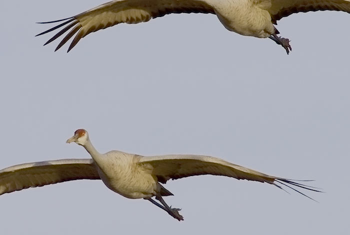
Glide Slope, Sandhill Cranes, Bosque National Wildlife Refuge, San Antonio NM, January 30, 2010
You'll find a larger version of this picture over on my Birds Series of photos.
This boy wants another new toy
I was kindly given the chance to play with a Canon EF 100-400mm f4.5-5.6L IS USM Telephoto Zoom Lens on my new Canon EOS 7D camera as the Sandhill Cranes and Snow Geese gathered at the roost this afternoon.
I was surprised to find I could easily hand hold this lens at 300mm and with occasional success even at 400mm, like in the image above. A 400mm focal length on this 1.6 x crop sensor camera is equivalent to a 640mm focal length on a 35mm full frame sensor camera. The camera would nearly always hold focus and the lens' onboard Image Stabilization system would deal with the camera shake if I was careful in following the flight path of the incoming birds. Taking bursts at 8 frames per second with the 7D sure filled up my 16 gig card in a hurry but it gave me lots of images to pick the best of the litter from.
An amazing combination. I want one. Thank you George.
Night camp
Site 16 - Bosque Bird Watcher's RV Park, San Antonio NM
- This is a basic, small Mom & Pop RV Park with full hookups.
- Verizon cell phone and Broadband service are available here with a strong signal.
- Locate Bosque Bird Watcher's RV Park on my Night Camps map
- Click for Google street view
- Check the weather in San Antonio NM
A Voyage and a Harbor
The native American was forced westward by the young escaping the limits of east coast villages that had been established only a generation or two earlier by parents escaping the limits of European villages. From then on, whether seeking a whale, rafting with Huck Finn, easy riding with Peter Fonda, or next week in Cancun, there has been a strong belief in America that happiness lies somewhere else. And yet as we find freedom we also rediscover loneliness. As geographer Yi-Fu Tuan says, we require both shelter and venture. We need freedom and support, silence and cacophony, the vast and distant but also the warm and near, a voyage and a harbor, the great adventure and the hobbit hole. Much of the iconography of our times gives little sense of this. Instead, the individual is treated as a self-sufficient, self-propelled vehicle moving across a background of other things, other places, and other people.